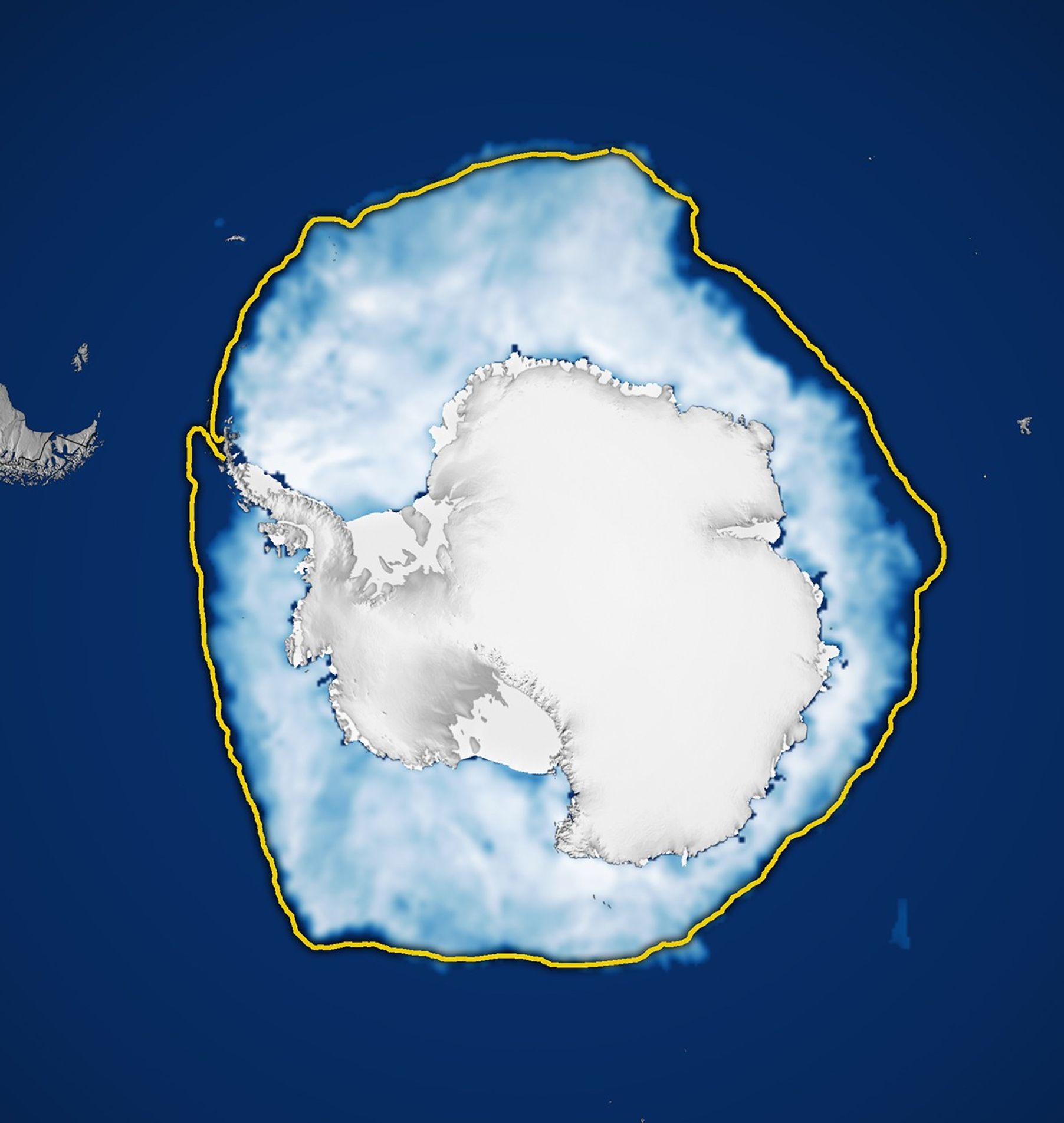
As winter 2025 loosened its grip on the Southern Hemisphere, sea ice around Antarctica continued to spread across the ocean’s surface. By September 17, it reached its maximum extent of the year, though that peak remained relatively low compared to levels observed before 2016.
On that day, Antarctic sea ice covered 17.81 million square kilometers (6.88 million square miles). This marks the third-lowest maximum in the 47-year satellite record and falls about 900,000 square kilometers (348,000 square miles) below the 1981-2010 average.
This map shows the sea ice extent (white) on September 17 compared to the 1981-2010 average extent for the same day (yellow line). Scientists calculate sea ice extent by dividing the ocean into a grid and summing the area of squares that meet a specific concentration threshold—those that are at least 15 percent covered by ice.
Although the region’s sea ice coverage remains low compared to pre-2016 observations, the Antarctic system’s complexity makes predicting and understanding these trends challenging, according to Nathan Kurtz, chief of the Cryospheric Sciences Laboratory at NASA’s Goddard Space Flight Center.
It’s not yet clear whether lower ice coverage in the Antarctic will persist, added Walt Meier, a scientist at the National Snow and Ice Data Center in Boulder, Colorado. “For now, we’re keeping an eye on it,” he said, to see if the lower sea ice levels around the South Pole are here to stay or only part of a passing phase.
NASA Earth Observatory images by Michala Garrison, using data from the National Snow and Ice Data Center. Story by James R. Riordon/NASA’s Earth Science News Team, adapted for Earth Observatory by Kathryn Hansen.
Stay up-to-date with the latest content from NASA as we explore the universe and discover more about our home planet.
Satellite data show that Arctic sea ice likely reached its annual minimum extent on September 10, 2025.
Nearly 50 years ago, the first Landsat satellite captured the rare sight of Mid-Atlantic waterways frozen over.
Icebreakers play a critical role in delivering supplies to America’s largest research base in Antarctica.
NASA’s Earth Observatory brings you the Earth, every day, with in-depth stories and stunning imagery.
Open access to NASA’s archive of Earth science data
NASA Earth (2025, September 17) Arctic Sea Ice Reaches Annual Low. Accessed November 13, 2025.
NASA Earth Observatory (2016, September 16) Sea Ice. Accessed November 13, 2025.
National Snow and Ice Data Center (2025, September 30) Antarctic sea ice maximum settles in third place. Accessed November 13, 2025.